
File:Medieval Livonia 1260.svg

Size of this PNG preview of this SVG file: 554 × 600 pixeles. Altri resolutiones: 222 × 240 pixeles | 443 × 480 pixeles | 709 × 768 pixeles | 946 × 1,024 pixeles | 1,891 × 2,048 pixeles | 955 × 1,034 pixeles.
Original file ((file SVG, nominalmen 955 × 1,034 pixeles, mesura de file: 734 KB))
Descrition
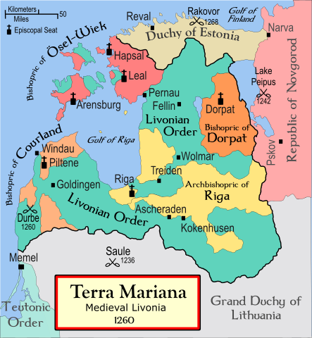
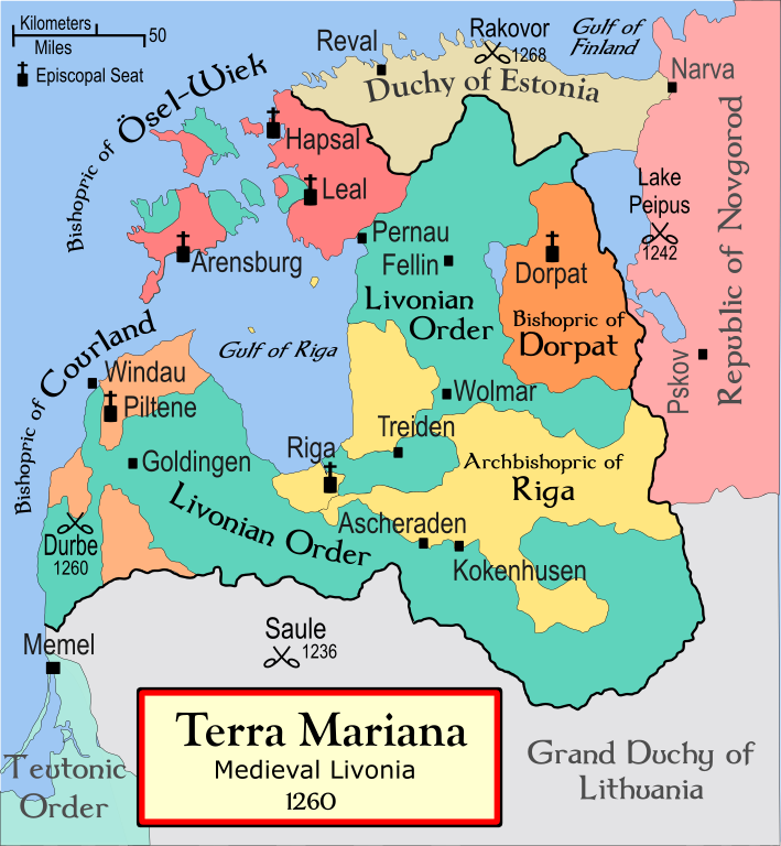
| Descrition | A political map of the Medieval Livonia, circa 1260, along with surrounding areas |
| Date | 13 novembre 2008 (original upload date) |
| Fonte | No machine-readable source provided. Own work assumed (based on copyright claims). |
| Autor | No machine-readable author provided. Termer assumed (based on copyright claims). |
| Other versions | Magyar |
Foreign language versions
References
- Turnbull, Stephen (2004) Crusader Castles of the Teutonic Knights (2), Osprey Publishing ISBN 1841767123
- Bjorklund, Oddvar; Holmboe, Haakon; Rohr, Anders (1970) Historical Atlas of the World, Barnes & Noble, NY, SBN: 389-00253-4.
- This 500 year old map of Lithuania, from UNESCO
- WHKMLA Historical Atlas - Estonia, accessed on November 2, 2006.
Autorisation
I, the copyright holder of this work, hereby publish it under the following license:

|
Permission es concedet por copiar, distribuer e/o modificar ti document sub li conditiones del Autorisation de Documentation Líber del GNU, Version 1.2 o qualcunc version posteriori publicat per li Free Software Foundation; che nequant Section Ínvariant, nequant Textu de Covriment, e nequant Textu de Contra-Covriment. Un copie del autorisation es includet in li section nominat Autorisation de Documentation Líber del GNU. |
| Ti file is autorisat sub li autorisation Creative Commons - Atribution-Distribution in Conditiones de Egal Autorisation 3.0 Non-Adaptat. | ||
Vu posse far in qualcunc forme rasonabil, ma ne de forma que suggeste que li autorisator indossa vu o tui usu.
| ||
| This licensing tag was added to this file as part of the GFDL licensing update. |
Versiones del file
Clacca a un date/témpore por vider ti version.
| Version de | Miniatura | Dimensiones | Usator | Comentarie | |
|---|---|---|---|---|---|
| actual | 03:40, 13 novembre 2008 | | 955 × 1,034 (734 KB) | Termer | == Summary == A political map of the Livonian Confederation, circa 1260, along with surrounding areas. *'''Comment''': The Livonian Confederation was established in 1418! The map needs a new name. I'd suggest '''Old Livonia |
Usu del file
Li sequent págine usa ti file:
Usu global del file
Li altri wikis a sequer usa ti-ci file:
- Usu in af.wikipedia.org
- Usu in ar.wikipedia.org
- Usu in bat-smg.wikipedia.org
- Usu in ba.wikipedia.org
- Usu in be-tarask.wikipedia.org
- Usu in be.wikipedia.org
- Usu in bg.wikipedia.org
- Usu in br.wikipedia.org
- Usu in ca.wikipedia.org
- Usu in cs.wikipedia.org
- Usu in da.wikipedia.org
Vider plu del usu global de ti-ci file.