File:Pelagie Islands map.png

Page contents not supported in other languages.
De Wikipedia

Original file(596 × 705 pixeles, dimension del file: 91 KB, tip MIME: image/png)

Ti file es de Wikimedia Commons e posse esser usat per altri projectes. Li descrition in su págine de descrition es monstrat in infra.

This locator map image could be re-created using vector graphics as an SVG file. This has several advantages; see Commons:Media for cleanup for more information. If an SVG form of this image is available, please upload it and afterwards replace this template with {{vector version available|new image name}}.


It is recommended to name the SVG file “Pelagie Islands map.svg”—then the template Vector version available (or Vva) does not need the new image name parameter.

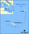
A map showing the location of the Pelagie Islands, including the islands Lampedusa, Linosa, and Lampione, in the Mediterranean Sea.

Blank version available at Image:Pelagie Islands blank map.png.

Created by NormanEinstein, May 25, 2005.

I, the copyright holder of this work, hereby publish it under the following licenses:
GNU head Permission es concedet por copiar, distribuer e/o modificar ti document sub li conditiones del Autorisation de Documentation Líber del GNU, Version 1.2 o qualcunc version posteriori publicat per li Free Software Foundation; che nequant Section Ínvariant, nequant Textu de Covriment, e nequant Textu de Contra-Covriment. Un copie del autorisation es includet in li section nominat Autorisation de Documentation Líber del GNU.
w:en:Creative Commons
atribution distribuer in conditiones de egal autorisation
Ti file is autorisat sub li autorisation Creative Commons - Atribution-Distribution in Conditiones de Egal Autorisation 3.0 Non-Adaptat.
Vu es líber:
  • distribuer – a copiar, distribuer e transmisser li labor
  • remixter – adaptar li ovre
Sub li conditiones quam seque:
  • atribution – Vu deve dar li credite convenent, provider un catenun por li autorisation, e indicar si changes esset fat.

Vu posse far in qualcunc forme rasonabil, ma ne de forma que suggeste que li autorisator indossa vu o tui usu.

  • distribuer in conditiones de egal autorisation – Si vu remixter, transformar, o constructer sur li materiale, vu deve distribuer tui contributiones sub li autorisation identic o campatabil quam li original.
This licensing tag was added to this file as part of the GFDL licensing update.
Vu posse selecter li autorisation de tui selection.

derivative works

Derivative works of this file:

Captions

Add a one-line explanation of what this file represents

Items portrayed in this file

depicts anglesi

copyrighted anglesi

Versiones del file

Clacca a un date/témpore por vider ti version.

Version deMiniaturaDimensionesUsatorComentarie
actual12:06, 3 junio 2012Miniatura del version de 12:06, 3 junio 2012596 × 705 (91 KB)Ras67cropped, opt.
07:56, 23 decembre 2006Miniatura del version de 07:56, 23 decembre 2006600 × 709 (114 KB)Hoshieadded Montenegro. under same license as original.
19:13, 25 may 2005Miniatura del version de 19:13, 25 may 2005600 × 709 (135 KB)NormanEinsteinA map showing the location of the Pelagie Islands, including the islands Lampedusa, Linosa, and Lampione, in the Mediterranean Sea. Created by NormanEinstein, May 25, 2005. {{GFDL-self}} Category:Maps of Italy

Li sequent págine usa ti file:

Usu global del file

Metadata