
File:Aerial view of Grindavík.jpg

Dimension de ci prevision: 800 × 530 pixeles. Altri resolutiones: 320 × 212 pixeles | 640 × 424 pixeles | 1,024 × 678 pixeles | 1,280 × 848 pixeles | 2,560 × 1,696 pixeles | 4,928 × 3,264 pixeles.
Original file (4,928 × 3,264 pixeles, dimension del file: 6.61 MB, tip MIME: image/jpeg)
Descrition
| Descrition |
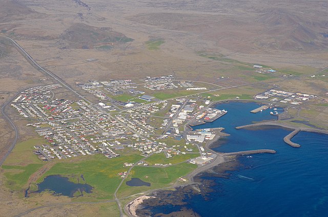
Deutsch: Luftbild von Grindavík mit den Bergen Hagafell (links) und Húsafell (rechts). |
| Date | |
| Fonte | Propri ovre |
| Autor | Olga Ernst |
| Object location | | View this and other nearby images on: OpenStreetMap |
|---|
Autorisation
I, the copyright holder of this work, hereby publish it under the following license:
This file is licensed under the Creative Commons Attribution-Share Alike 4.0 International license.
- Vu es líber:
- distribuer – a copiar, distribuer e transmisser li labor
- remixter – adaptar li ovre
- Sub li conditiones quam seque:
- atribution – Vu deve dar li credite convenent, provider un catenun por li autorisation, e indicar si changes esset fat.
Vu posse far in qualcunc forme rasonabil, ma ne de forma que suggeste que li autorisator indossa vu o tui usu.
- distribuer in conditiones de egal autorisation – Si vu remixter, transformar, o constructer sur li materiale, vu deve distribuer tui contributiones sub li autorisation identic o campatabil quam li original.
| Annotations | This image is annotated: View the annotations at Commons |
Versiones del file
Clacca a un date/témpore por vider ti version.
| Version de | Miniatura | Dimensiones | Usator | Comentarie | |
|---|---|---|---|---|---|
| actual | 12:34, 8 junio 2022 | | 4,928 × 3,264 (6.61 MB) | Olga Ernst | Uploaded own work with UploadWizard |
Usu del file
Li sequent págine usa ti file:
Usu global del file
Li altri wikis a sequer usa ti-ci file:
- Usu in arz.wikipedia.org
- Usu in ca.wikipedia.org
- Usu in ceb.wikipedia.org
- Usu in cs.wikipedia.org
- Usu in cy.wikipedia.org
- Usu in da.wikipedia.org
- Usu in de.wikipedia.org
- Usu in de.wikivoyage.org
- Usu in el.wikipedia.org
- Usu in en.wikipedia.org
- Usu in en.wikivoyage.org
- Usu in et.wikipedia.org
- Usu in eu.wikipedia.org
- Usu in fr.wikipedia.org
- Usu in he.wikipedia.org
- Usu in he.wikivoyage.org
- Usu in is.wikipedia.org
- Usu in it.wikivoyage.org
- Usu in mdf.wikipedia.org
- Usu in no.wikipedia.org
- Usu in os.wikipedia.org
- Usu in pt.wikipedia.org
- Usu in sr.wikipedia.org
- Usu in vo.wikipedia.org
- Usu in www.wikidata.org