
File:Argentina orthographic.svg

Size of this PNG preview of this SVG file: 550 × 550 pixeles. Altri resolutiones: 240 × 240 pixeles | 480 × 480 pixeles | 768 × 768 pixeles | 1,024 × 1,024 pixeles | 2,048 × 2,048 pixeles.
Original file ((file SVG, nominalmen 550 × 550 pixeles, mesura de file: 691 KB))
Descrition
| Descrition |
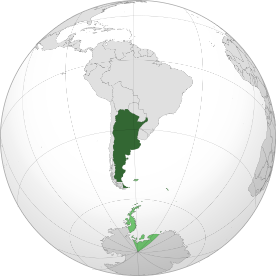
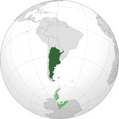
English: Orthographic map of Argentina centered on Buenos Aires
Official territory.
Claimed territories. Español: Mapa ortográfico de la Argentina centrado en Buenos Aires
Territorio oficial.
Territorios en disputa. |
| Date | |
| Fonte | Propri ovre with Natural Earth Data |
| Autor | Addicted04 |
| SVG genesis |
El único territorio que reclama son las malvinas, son los puntos verdes chiquitos, la antártida o el triangulo de abajo es argentino.
.svg)
.svg)
.svg)
.svg)
.svg)
.svg)
.svg)
.svg)
.svg)
.svg)
.svg)
.svg)
.svg)
.svg)
.svg)
.svg)
.svg)
.svg)
.svg)
.svg)
.svg)
.svg)
.svg)
.svg)
.svg)
.svg)
.svg)
.svg)
.svg)
.svg)
.svg)
.svg)
.svg)
.svg)
.svg)
.svg)
.svg)
.svg)
.svg)
.svg)
.svg)
.svg)
.svg)
.svg)
.svg)
.svg)
.svg)
.svg)
.svg)
.svg)
.svg)
.svg)
.svg)
.svg)
.svg)
.svg)
.svg)
.svg)
.svg)
.svg)
.svg)
.svg)
.svg)
.svg)
.svg)
.svg)
.svg)
.svg)
.svg)
.svg)
.svg)
.svg)
.svg)
.svg)

.svg)

.svg)

.svg)
.svg)
.svg)
.svg)
.svg)
.svg)
.svg)


.svg)
.svg)
.svg)
.svg)
.svg)
.svg)
.svg)

.svg)
.svg)
.svg)
.svg)
.svg)
.svg)
.svg)
.svg)
.svg)

.svg)
.svg)
.svg)
.svg)
.svg)
.svg)
.svg)
_without_national_boundaries.svg)
.svg)
.svg)
.svg)
.svg)
.svg)
.svg)

.svg)
.svg)
.png)
.svg)
.svg)
.svg)
.svg)

.svg)
.svg)
.svg)
.svg)
.svg)
.svg)
.svg)
.svg)
.svg)
.svg)
.svg)

.svg)
.svg)
.svg)
.svg)
.svg)
.svg)
.svg)
.svg)
.svg)

.svg)
.svg)

.svg)
.svg)
.svg)
.svg)
.svg)
.svg)
.svg)
.svg)
.svg)
.svg)
.svg)
.svg)
.svg)
.svg)
.svg)
.svg)
.svg)
.svg)
.svg)
.svg)
.svg)
.svg)
.svg)
.svg)
.svg)
.svg)
.svg)
_-_Crimea_disputed.svg)
.svg)
.svg)
.svg)
.svg)
.svg)
.svg)
.svg)
.svg)
.svg)
.svg)
.svg)
_political.svg)
.svg)
.svg)
.svg)
.svg)
_-_Crimea_disputed_-_no_borders.svg)
.svg)
.svg)
.svg)
.svg)
.svg)
.svg)
.svg)
.svg)
.svg)
.svg)
.svg)

.svg)
.svg)
.svg)

.png)
.svg)
.svg)
.svg)
.svg)
.svg)
.svg)
.svg)
.svg)
.svg)
.svg)
.svg)
.svg)
.svg)
.svg)
.svg)
.svg)
.svg)
.svg)
.svg)
.svg)
.svg)
.svg)
.svg)
.svg)
.svg)
.svg)
.svg)
.svg)
.svg)
.svg)
.svg)
.svg)
.svg)
.svg)
.png)
.svg)
.svg)
.svg)
_(orthographic_projection).png)
| Orthographic projections maps created by Ssolbergj |
|---|
| Orthographic projections maps created by Ssolbergj: |
.svg)
.svg)
Autorisation
I, the copyright holder of this work, hereby publish it under the following license:
This file is licensed under the Creative Commons Attribution 3.0 Unported license.
- Vu es líber:
- distribuer – a copiar, distribuer e transmisser li labor
- remixter – adaptar li ovre
- Sub li conditiones quam seque:
- atribution – Vu deve dar li credite convenent, provider un catenun por li autorisation, e indicar si changes esset fat.
Vu posse far in qualcunc forme rasonabil, ma ne de forma que suggeste que li autorisator indossa vu o tui usu.
Versiones del file
Clacca a un date/témpore por vider ti version.
| Version de | Miniatura | Dimensiones | Usator | Comentarie | |
|---|---|---|---|---|---|
| actual | 16:48, 18 julí 2013 | | 550 × 550 (691 KB) | Montgomery | Reverted to version as of 22:50, 22 October 2011; COM:GL/M standars |
| 16:08, 18 julí 2013 |  | 550 × 550 (697 KB) | Cesardavidd | Reverted to version as of 20:32, 22 June 2011 | |
| 22:50, 22 octobre 2011 |  | 550 × 550 (691 KB) | Addicted04 | claimed color | |
| 22:39, 22 octobre 2011 |  | 550 × 550 (690 KB) | Addicted04 | claimed color | |
| 20:32, 22 junio 2011 |  | 550 × 550 (697 KB) | Addicted04 | latitude line | |
| 21:08, 21 junio 2011 |  | 550 × 550 (692 KB) | Addicted04 |
Usu del file
Li sequent págine usa ti file:
Usu global del file
Li altri wikis a sequer usa ti-ci file:
- Usu in an.wikipedia.org
- Usu in ar.wikipedia.org
- Usu in as.wikipedia.org
- Usu in av.wikipedia.org
- Usu in awa.wikipedia.org
- Usu in ay.wikipedia.org
- Usu in azb.wikipedia.org
- Usu in bh.wikipedia.org
- Usu in bm.wikipedia.org
- Usu in bn.wikipedia.org
- Usu in bo.wikipedia.org
- Usu in bpy.wikipedia.org
- Usu in br.wikipedia.org
- Usu in bxr.wikipedia.org
- Usu in ca.wikipedia.org
- Usu in cbk-zam.wikipedia.org
- Usu in cdo.wikipedia.org
- Usu in ceb.wikipedia.org
- Usu in chr.wikipedia.org
- Usu in ch.wikipedia.org
- Usu in co.wikipedia.org
- Usu in crh.wikipedia.org
- Usu in cv.wikipedia.org
- Usu in de.wiktionary.org
- Usu in dsb.wikipedia.org
- Usu in dty.wikipedia.org
- Usu in ee.wikipedia.org
- Usu in en.wikipedia.org
- Usu in es.wikipedia.org
- Categoría:Provincia de Buenos Aires
- Categoría:Provincia de Catamarca
- Categoría:Provincia de Chaco
- Categoría:Provincia de Córdoba (Argentina)
- Categoría:Provincia de Corrientes
- Categoría:Provincia de Entre Ríos
- Categoría:Provincia de Formosa
- Categoría:Provincia de Jujuy
- Categoría:Provincia de La Pampa
- Categoría:Provincia de La Rioja (Argentina)
- Categoría:Provincia de Mendoza
- Categoría:Provincia de Río Negro
- Categoría:Provincia de Salta
Vider plu del usu global de ti-ci file.