
File:Argentina topo blank.jpg

Dimension de ci prevision: 445 × 599 pixeles. Altri resolutiones: 178 × 240 pixeles | 357 × 480 pixeles | 571 × 768 pixeles | 761 × 1,024 pixeles | 1,600 × 2,153 pixeles.
Original file (1,600 × 2,153 pixeles, dimension del file: 565 KB, tip MIME: image/jpeg)
| Descrition |
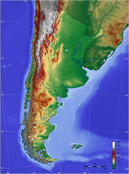
Español: Mapa de Argentina con su relieve
English: Map of Argentina with its terrain levels |
||||||||||
| Date | 9/06/2006 | ||||||||||
| Fonte | See below | ||||||||||
| Autor | Captain Blood | ||||||||||
| Permission: (Reusant ti-ci file) |
|

Versiones del file
Clacca a un date/témpore por vider ti version.
| Version de | Miniatura | Dimensiones | Usator | Comentarie | |
|---|---|---|---|---|---|
| actual | 21:45, 13 may 2009 | | 1,600 × 2,153 (565 KB) | Keysanger | reverted. (Deleted yellow line in the Straits of Magellan, added the definitive end of the controversial border at the Beagle Channel and marked with a white box the (last) undefined border zone as agreed both countries.) |
| 04:10, 5 may 2009 |  | 1,600 × 2,153 (867 KB) | Dexxter | Reverted to version as of 18:57, 9 June 2006 | |
| 20:13, 4 junio 2008 |  | 1,600 × 2,153 (565 KB) | Keysanger | Argentina topo deleted yellow line in the Straits of Magellan, added the definitive end of the controversial border at the Beagle Channel and marked with a white box the (last) undefined border zone as agreed both countries. [[Category:[[Category:Topograp | |
| 18:57, 9 junio 2006 |  | 1,600 × 2,153 (867 KB) | Captain Blood~commonswiki | {{Bild-GFDL-GMT}} |
Usu del file
Hay nequant págine que usa ti file.
Usu global del file
Li altri wikis a sequer usa ti-ci file:
- Usu in bg.wikipedia.org
- Usu in bn.wikipedia.org
- Usu in ca.wikipedia.org
- Usu in ckb.wikipedia.org
- Usu in dz.wikipedia.org
- Usu in ee.wikipedia.org
- Usu in el.wikipedia.org
- Usu in en.wikipedia.org
- Usu in eo.wikipedia.org
- Usu in es.wikipedia.org
- Usu in eu.wikipedia.org
- Usu in fa.wikipedia.org
- Usu in fi.wikipedia.org
- Usu in fr.wikipedia.org
- Usu in gcr.wikipedia.org
- Usu in hu.wikipedia.org
- Usu in hy.wikipedia.org
- Usu in incubator.wikimedia.org
- Usu in io.wikipedia.org
- Usu in it.wikipedia.org
- Usu in ja.wikipedia.org
- Usu in ka.wikipedia.org
- Usu in kbd.wikipedia.org
- Usu in ko.wikipedia.org
- Usu in ml.wikipedia.org
- Usu in ms.wikipedia.org
- Usu in mt.wikipedia.org
- Usu in pl.wikipedia.org
- Usu in pt.wikipedia.org
Vider plu del usu global de ti-ci file.