
File:Asia 800ad.jpg
Dimension de ci prevision: 800 × 463 pixeles. Altri resolutiones: 320 × 185 pixeles | 640 × 370 pixeles | 1,024 × 593 pixeles | 1,280 × 741 pixeles | 2,099 × 1,215 pixeles.
Original file (2,099 × 1,215 pixeles, dimension del file: 809 KB, tip MIME: image/jpeg)

|
This historical map image could be re-created using vector graphics as an SVG file. This has several advantages; see Commons:Media for cleanup for more information. If an SVG form of this image is available, please upload it and afterwards replace this template with
{{vector version available|new image name}}.
It is recommended to name the SVG file “Asia 800ad.svg”—then the template Vector version available (or Vva) does not need the new image name parameter. |


Descrition
| Descrition |
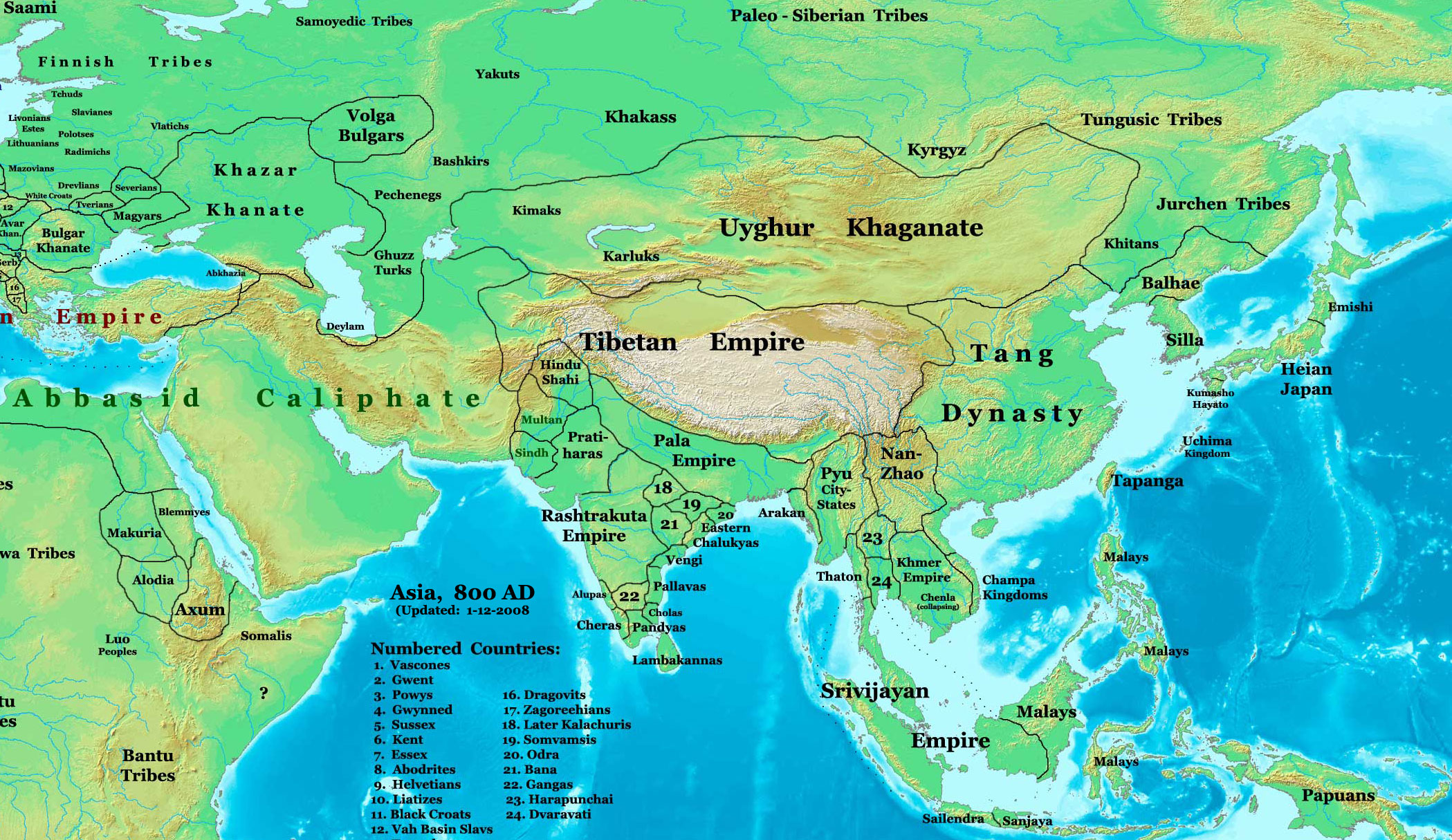
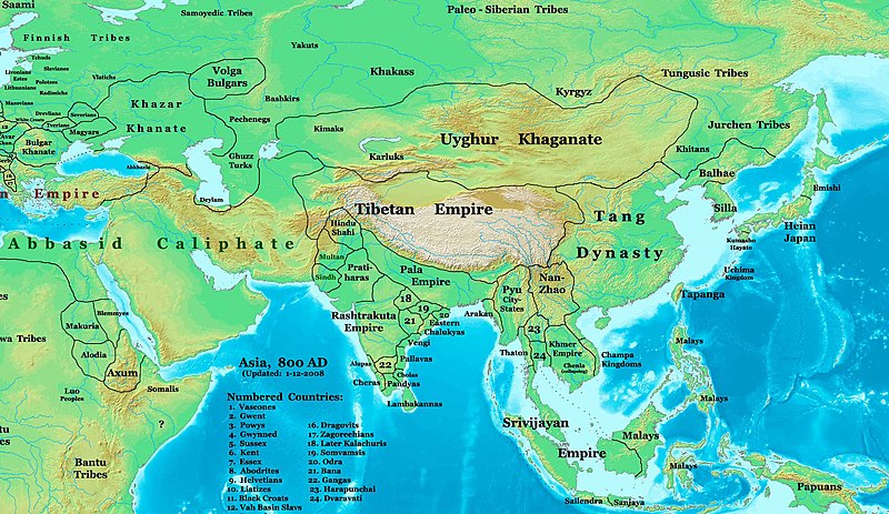
English: This image is a zoomed-in version of Image:East-Hem_800ad.jpg (Eastern Hemisphere in 800 AD).
Author: Thomas A. Lessman. Source URL: http://www.ThomasLessman.com/History/images/East-Hem_800ad.jpg. Image was created by me (Thomas Lessman) based on map of Eastern Hemisphere in 800 AD. Image is free for public and/or educational use. I would appreciate a mention if this image is used elsewhere. If anyone is interested in helping further this work, please contact Thomas Lessman at talessman@yis.us. Other Historical Maps by Thomas Lessman
|
| Date | 22 octobre 2007 (original upload date); 29 januar 2008 (last version) |
| Fonte | Transferred from en.wikipedia to Commons by Vinhtantran using CommonsHelper. |
| Autor | Talessman at anglesi Wikipedia |
| Other versions |
 |


Autorisation
Talessman at anglesi Wikipedia, the copyright holder of this work, hereby publishes it under the following licenses:

|
Permission es concedet por copiar, distribuer e/o modificar ti document sub li conditiones del Autorisation de Documentation Líber del GNU, Version 1.2 o qualcunc version posteriori publicat per li Free Software Foundation; che nequant Section Ínvariant, nequant Textu de Covriment, e nequant Textu de Contra-Covriment. Un copie del autorisation es includet in li section nominat Autorisation de Documentation Líber del GNU. |
This file is licensed under the Creative Commons Attribution 3.0 Unported license.
Atribution: Talessman at anglesi Wikipedia
- Vu es líber:
- distribuer – a copiar, distribuer e transmisser li labor
- remixter – adaptar li ovre
- Sub li conditiones quam seque:
- atribution – Vu deve dar li credite convenent, provider un catenun por li autorisation, e indicar si changes esset fat.
Vu posse far in qualcunc forme rasonabil, ma ne de forma que suggeste que li autorisator indossa vu o tui usu.
Vu posse selecter li autorisation de tui selection.
Original upload log
The original description page was here. All following user names refer to en.wikipedia.
- 2008-01-29 22:50 Talessman 2099×1215×8 (828763 bytes) corrected borders of Tibet and others
- 2007-12-10 23:50 Talessman 2106×1450×8 (911289 bytes) (Correct image uploaded this time; earlier upload was the old version...)
- 2007-12-10 23:48 Talessman 1950×1193×8 (695931 bytes) Uploaded most recently corrected version (as of 12-09-2007)
- 2007-10-31 20:39 Talessman 1950×1193×8 (695931 bytes) Corrected borders of Korea, added info on Far eastern islands
- 2007-10-22 19:15 Talessman 1673×1062×8 (553343 bytes) Author: Thomas A. Lessman. Source URL: http://www.ThomasLessman.com/History/images/East-Hem_800ad.jpg. Image was created by me (Thomas Lessman) based on map of Eastern Hemisphere in 800AD. Image is free for public and/or educational use. I would appreciat
Versiones del file
Clacca a un date/témpore por vider ti version.
| Version de | Miniatura | Dimensiones | Usator | Comentarie | |
|---|---|---|---|---|---|
| actual | 04:46, 23 junio 2008 | | 2,099 × 1,215 (809 KB) | File Upload Bot (Magnus Manske) | {{BotMoveToCommons|en.wikipedia}} {{Information |Description={{en|This image is a zoomed-in version of [http://en.wikipedia.org/wiki/Image:East-Hem_800ad.jpg Eastern Hemisphere in 800 AD]. [[:en:Image:East-Hem_800ad.jpg|thumb|300px|left|Eastern Hemispher |
Usu del file
Hay nequant págine que usa ti file.
Usu global del file
Li altri wikis a sequer usa ti-ci file:
- Usu in azb.wikipedia.org
- Usu in ba.wikipedia.org
- Usu in bn.wikipedia.org
- Usu in en.wikipedia.org
- Bangladesh
- West Bengal
- History of Bangladesh
- Jaisalmer
- Portal:Bangladesh
- Gauḍa (city)
- History of Bihar
- Śāntarakṣita
- Pataliputra
- History of Rajasthan
- Horses in East Asian warfare
- Jaisalmer State
- User:Joelton Ivson/Gather lists/24270 – India
- User:Gauravkumar4291/Notes/GS/Cul/Pala Empire
- Horses in ancient and Imperial China
- Usu in fa.wikipedia.org
- Usu in fr.wikipedia.org
- Usu in hi.wikipedia.org
- Usu in incubator.wikimedia.org
- Usu in it.wikipedia.org
- Usu in ka.wikipedia.org
- Usu in kn.wikipedia.org
- Usu in ko.wikipedia.org
- Usu in mai.wikipedia.org
- Usu in my.wikipedia.org
- Usu in ne.wikipedia.org
- Usu in pt.wikipedia.org
- Usu in ru.wikipedia.org
- Usu in sl.wikipedia.org
- Usu in ta.wikipedia.org
- Usu in te.wikipedia.org
- Usu in tt.wikipedia.org
- Usu in uk.wikipedia.org
- Usu in vi.wikipedia.org