
File:CzechRepCitiesTowns.png

Dimension de ci prevision: 800 × 474 pixeles. Altri resolutiones: 320 × 190 pixeles | 640 × 379 pixeles | 930 × 551 pixeles.
Original file (930 × 551 pixeles, dimension del file: 35 KB, tip MIME: image/png)
| Descrition |
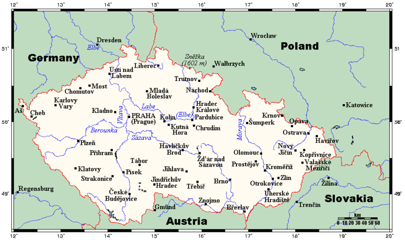
English: A map showing the Czech Republic's main cities and towns, and nearby areas in neighbouring countries. This map's source is here, with the uploader's modifications, and the GMT homepage says that the tools are released under the GNU General Public License. |
| Date | 26 julí 2007 (original upload date) |
| Fonte | Transferred from en.wikipedia to Commons by Georgez. |
| Autor | Kelisi at anglesi Wikipedia |
Autorisation
Kelisi from en.wikipedia.org, the copyright holder of this work, hereby publishes it under the following license:
| Ti file is autorisat sub li autorisation Creative Commons - Atribution-Distribution in Conditiones de Egal Autorisation 3.0 Non-Adaptat. Subject to disclaimers. | ||
| Atribution: Kelisi from en.wikipedia.org | ||
Vu posse far in qualcunc forme rasonabil, ma ne de forma que suggeste que li autorisator indossa vu o tui usu.
| ||
| This licensing tag was added to this file as part of the GFDL licensing update. |

|
Permission es concedet por copiar, distribuer e/o modificar ti document sub li conditiones del Autorisation de Documentation Líber del GNU, Version 1.2 o qualcunc version posteriori publicat per li Free Software Foundation; che nequant Section Ínvariant, nequant Textu de Covriment, e nequant Textu de Contra-Covriment. Un copie del autorisation es includet in li section nominat Autorisation de Documentation Líber del GNU. Subject to disclaimers. |
Original upload log
The original description page was here. All following user names refer to en.wikipedia.
- 2007-07-26 22:40 Kelisi 930×551× (32250 bytes) oops
- 2007-07-26 22:38 Kelisi 930×551× (32273 bytes) Adding Sněžka.
- 2007-07-15 17:09 Kelisi 930×551× (31855 bytes) == Summary == A map showing the Czech Republic's main cities and towns, and nearby areas in neighbouring countries. This map's source is [http://www.aquarius.ifm-geomar.de/ here], with the uploader's modifications, and the [http://gmt.soest.hawaii.edu/ GM
Versiones del file
Clacca a un date/témpore por vider ti version.
| Version de | Miniatura | Dimensiones | Usator | Comentarie | |
|---|---|---|---|---|---|
| actual | 17:21, 10 februar 2012 | | 930 × 551 (35 KB) | Miaow Miaow | added city of Opava |
| 16:15, 10 februar 2012 |  | 930 × 551 (32 KB) | Miaow Miaow | removed Líšeň (presumably a tongue-in-cheek addition by the original creator ?), which is merely a suburb of Brno and of much less importance than other cities depicted | |
| 15:57, 25 marte 2009 |  | 930 × 551 (31 KB) | Georgez | {{Information |Description={{en|A map showing the Czech Republic's main cities and towns, and nearby areas in neighbouring countries. This map's source is [http://www.aquarius.ifm-geomar.de/ here], with the uploader's modifications, and the [http://gmt.so |
Usu del file
Hay nequant págine que usa ti file.
Usu global del file
Li altri wikis a sequer usa ti-ci file:
- Usu in ar.wikipedia.org
- Usu in bs.wikipedia.org
- Usu in el.wikipedia.org
- Usu in en.wikipedia.org
- Usu in ja.wikipedia.org
- Usu in lt.wikipedia.org
- Usu in mk.wikipedia.org
- Usu in pt.wikipedia.org