
File:Detailed SVG map of the Anglophone world.svg

Size of this PNG preview of this SVG file: 800 × 411 pixeles. Altri resolutiones: 320 × 164 pixeles | 640 × 329 pixeles | 1,024 × 526 pixeles | 1,280 × 657 pixeles | 2,560 × 1,314 pixeles.
Original file ((file SVG, nominalmen 2,560 × 1,314 pixeles, mesura de file: 1.38 MB))
Descrition
| Descrition |
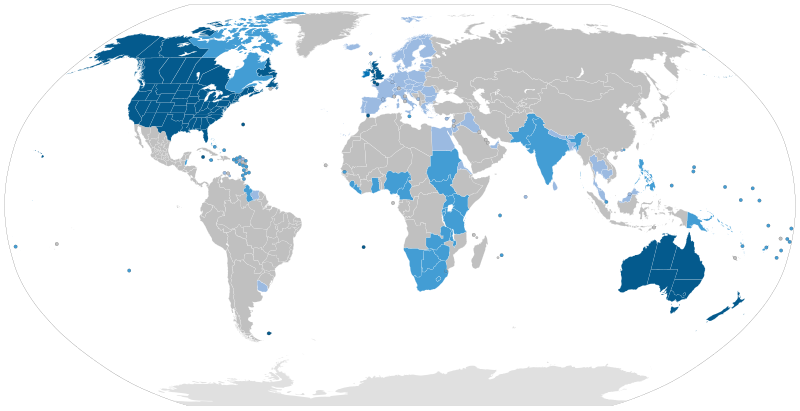
English: Majority native language
Co-official and majority native language
Official but minority native language
Secondary language: spoken as a second language by more than 20% of the population, de facto working language of government, language of instruction in education, etc. |
| Date | |
| Fonte | Speaker figures based on Ethnologue and other sources. Blank map: File:BlankMap-World6-Subdivisions.svg |
| Autor | Jpthefish |
Autorisation
I, the copyright holder of this work, hereby publish it under the following license:
This file is licensed under the Creative Commons Attribution-Share Alike 4.0 International license.
- Vu es líber:
- distribuer – a copiar, distribuer e transmisser li labor
- remixter – adaptar li ovre
- Sub li conditiones quam seque:
- atribution – Vu deve dar li credite convenent, provider un catenun por li autorisation, e indicar si changes esset fat.
Vu posse far in qualcunc forme rasonabil, ma ne de forma que suggeste que li autorisator indossa vu o tui usu.
- distribuer in conditiones de egal autorisation – Si vu remixter, transformar, o constructer sur li materiale, vu deve distribuer tui contributiones sub li autorisation identic o campatabil quam li original.
Versiones del file
Clacca a un date/témpore por vider ti version.
| Version de | Miniatura | Dimensiones | Usator | Comentarie | |
|---|---|---|---|---|---|
| actual | 09:51, 26 august 2023 | | 2,560 × 1,314 (1.38 MB) | Kwamikagami | rv: you just removed light blue, which we use on other maps |
| 01:35, 26 august 2023 |  | 2,560 × 1,314 (1.36 MB) | Jpthefish | Reverted to version as of 01:23, 3 July 2020 (UTC) Forgive me if I am mistaken, but I have not seen sources to corroborate the light blue coloring of the EU, SE Asia, or other regions. The light blue color in my other maps was previously reserved for lanauges with cultural or secondary status - that is, a historically significant language and/or a language spoken by over 20% of the native population. I am open to changes though, as long as they are consistent across all SVG maps and reflect a... | |
| 05:42, 9 august 2023 |  | 2,560 × 1,314 (1.38 MB) | Kwamikagami | some countries marked as majority English were majority creole | |
| 06:33, 15 januar 2023 |  | 2,560 × 1,314 (1.38 MB) | Kwamikagami | clean up Quebec; Faroes assumed | |
| 05:50, 15 januar 2023 |  | 2,560 × 1,314 (1.38 MB) | Kwamikagami | 2nd language >20%, & de facto govt working language, per Ethnologue. | |
| 01:23, 3 julí 2020 |  | 2,560 × 1,314 (1.36 MB) | Jpthefish | New section | |
| 22:47, 8 junio 2020 |  | 2,560 × 1,314 (1.36 MB) | Jpthefish | Lighter secondary colors | |
| 17:17, 25 may 2020 |  | 2,560 × 1,314 (1.36 MB) | Jpthefish | edit Channel Islands | |
| 18:19, 8 may 2020 |  | 2,560 × 1,314 (1.36 MB) | Jpthefish | Add Cameroon | |
| 02:15, 8 may 2020 |  | 2,560 × 1,314 (1.36 MB) | Jpthefish | Uploaded own work with UploadWizard |
Usu del file
Hay nequant págine que usa ti file.
Usu global del file
Li altri wikis a sequer usa ti-ci file:
- Usu in af.wikipedia.org
- Usu in ang.wikipedia.org
- Usu in ar.wikipedia.org
- Usu in ast.wikipedia.org
- Usu in av.wikipedia.org
- Usu in az.wikipedia.org
- Usu in ba.wikipedia.org
- Usu in be.wikipedia.org
- Usu in bg.wikipedia.org
- Usu in bn.wikipedia.org
- Usu in br.wikipedia.org
- Usu in cv.wikipedia.org
- Usu in en.wikipedia.org
- Usu in en.wikibooks.org
- Usu in es.wikipedia.org
- Usu in fa.wikipedia.org
- Usu in fr.wikipedia.org
- Usu in ga.wikipedia.org
- Usu in guc.wikipedia.org
- Usu in he.wikipedia.org
- Usu in hr.wikipedia.org
- Usu in hy.wikipedia.org
- Usu in id.wikipedia.org
- Usu in incubator.wikimedia.org
- Usu in it.wikipedia.org
Vider plu del usu global de ti-ci file.