File:Geographic distribution of Bengali language.png

Page contents not supported in other languages.
De Wikipedia

Original file(2,806 × 2,080 pixeles, dimension del file: 1.36 MB, tip MIME: image/png)

Ti file es de Wikimedia Commons e posse esser usat per altri projectes. Li descrition in su págine de descrition es monstrat in infra.

Descrition

Descrition
Ελληνικά: Γεωγραφική κατανομή της Βεγγαλικής Γλώσσας ανά επαρχία της Ινδίας και στο Μπανγκλαντές, τα χρώματα στις επαρχίες ποικίλουν ανάλογα με το ποσοστό ομιλητών (δεδομένα απογραφής 2011). Παράγωγο του αρχείου India district map (de-facto).svg.
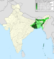
English: Geographic distribution of Bengali language in India and Bangladesh. The map covers each district of India and the five shades of green show the percentage of Bengali language speakers in each district. Source: Indian census 2011. Feel free to enrich the map with data for more Indian districts, or fix any mistakes. Derivative of the file India district map (de-facto).svg.
Date
Fonte Propri ovre
Autor NikosLikomitros

Autorisation

I, the copyright holder of this work, hereby publish it under the following license:
w:en:Creative Commons
atribution distribuer in conditiones de egal autorisation
This file is licensed under the Creative Commons Attribution-Share Alike 4.0 International license.
Vu es líber:
  • distribuer – a copiar, distribuer e transmisser li labor
  • remixter – adaptar li ovre
Sub li conditiones quam seque:
  • atribution – Vu deve dar li credite convenent, provider un catenun por li autorisation, e indicar si changes esset fat.

Vu posse far in qualcunc forme rasonabil, ma ne de forma que suggeste que li autorisator indossa vu o tui usu.

  • distribuer in conditiones de egal autorisation – Si vu remixter, transformar, o constructer sur li materiale, vu deve distribuer tui contributiones sub li autorisation identic o campatabil quam li original.

Captions

Add a one-line explanation of what this file represents
Geographic distribution of Bengali language in India and Bangladesh. The map covers each district of India and the five shades of green show the percentage of Bengali language speakers in each district. Source: Indian census 2011.

Items portrayed in this file

depicts anglesi

copyrighted anglesi

inception anglesi

26 junio 2022

media type anglesi

image/png

Versiones del file

Clacca a un date/témpore por vider ti version.

Version deMiniaturaDimensionesUsatorComentarie
actual15:05, 2 julí 2022Miniatura del version de 15:05, 2 julí 20222,806 × 2,080 (1.36 MB)NikosLikomitrosA few districts of Arunachal Pradesh have a notable Bengali presence above of 1%, probably part of the Indian efforts to increase its presence in the region.
16:55, 1 julí 2022Miniatura del version de 16:55, 1 julí 20222,806 × 2,080 (1.36 MB)NikosLikomitrosTwo extra fixes.
16:53, 1 julí 2022Miniatura del version de 16:53, 1 julí 20222,806 × 2,080 (1.36 MB)NikosLikomitrosMinor fixes.
16:44, 1 julí 2022Miniatura del version de 16:44, 1 julí 20222,806 × 2,080 (1.36 MB)NikosLikomitrosNow, this map covers all districts of India. Includes also extra information and a new colour key. The basemap is from Distribution_of_Jats_in_South_Asia.png.
21:09, 26 junio 2022Miniatura del version de 21:09, 26 junio 20221,902 × 2,048 (1,002 KB)NikosLikomitrosUploaded own work with UploadWizard

Hay nequant págine que usa ti file.

Usu global del file

Li altri wikis a sequer usa ti-ci file:

Metadata