
File:Island of Ireland location map Galway.svg

Size of this PNG preview of this SVG file: 481 × 599 pixeles. Altri resolutiones: 192 × 240 pixeles | 385 × 480 pixeles | 616 × 768 pixeles | 822 × 1,024 pixeles | 1,643 × 2,048 pixeles | 1,450 × 1,807 pixeles.
Original file ((file SVG, nominalmen 1,450 × 1,807 pixeles, mesura de file: 642 KB))
| Descrition |
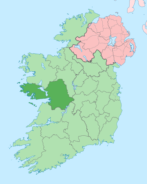
English: The island of Ireland, showing international border between Ireland and Northern Ireland, traditional provinces, traditional counties, and local authority areas in Ireland and Northern Ireland. |
| Date | (UTC) |
| Fonte | |
| Autor |
|
| This is a retouched picture, which means that it has been digitally altered from its original version. Modifications: Coloured in regions with county of article highlighted. The original can be viewed here: Island of Ireland location map.svg:
|
I, the copyright holder of this work, hereby publish it under the following license:
Ti file is autorisat sub li autorisation Creative Commons - Atribution-Distribution in Conditiones de Egal Autorisation 3.0 Non-Adaptat.
- Vu es líber:
- distribuer – a copiar, distribuer e transmisser li labor
- remixter – adaptar li ovre
- Sub li conditiones quam seque:
- atribution – Vu deve dar li credite convenent, provider un catenun por li autorisation, e indicar si changes esset fat.
Vu posse far in qualcunc forme rasonabil, ma ne de forma que suggeste que li autorisator indossa vu o tui usu.
- distribuer in conditiones de egal autorisation – Si vu remixter, transformar, o constructer sur li materiale, vu deve distribuer tui contributiones sub li autorisation identic o campatabil quam li original.
Original upload log
This image is a derivative work of the following images:
- File:Island_of_Ireland_location_map.svg licensed with Cc-by-sa-3.0
- 2010-03-06T20:43:33Z Rannpháirtí anaithnid 1450x1807 (679207 Bytes) Fix incorrectly coloured isands.
- 2010-03-03T22:19:29Z Rannpháirtí anaithnid 1450x1807 (679744 Bytes) {{Information |Description={{de|Positionskarte von [[:de:Irland|Irland]]}} Quadratische Plattkarte, N-S-Streckung 170 %. Geographische Begrenzung der Karte: * N: 55.6° N * S: 51.2° N * W: 11.0° W * O: 5.0° W {{en|Location
Uploaded with derivativeFX
Versiones del file
Clacca a un date/témpore por vider ti version.
| Version de | Miniatura | Dimensiones | Usator | Comentarie | |
|---|---|---|---|---|---|
| actual | 14:00, 28 junio 2020 | | 1,450 × 1,807 (642 KB) | Chipmunkdavis | Per the Local Government Reform Act 2014, joining both Tipperarys and both Waterfords (and removing Limerick City code). Colouring in islands, cleaning up and grouping code to remove stray objects and show Galway and Lough Ree. |
| 00:44, 19 julí 2010 |  | 1,450 × 1,807 (816 KB) | Mabuska | {{Information |Description={{en|The island of Ireland, showing international border between Northern Ireland and Republic of Ireland, traditional provinces, traditional counties, and local authority areas in the Republic of Ireland and Northern Ireland.}} |
Usu del file
Li sequent págine usa ti file:
Usu global del file
Li altri wikis a sequer usa ti-ci file:
- Usu in ar.wikipedia.org
- Usu in ast.wikipedia.org
- Usu in bg.wikipedia.org
- Usu in ca.wikipedia.org
- Comtat de Galway
- Galway
- Athenry
- An Spidéal
- Tuam
- Kinvara
- Plantilla:Comtat Galway
- Ballinasloe
- Gort
- Loughrea
- Baile na hAbhann
- Casla (Irlanda)
- Béal an Daingin
- Camus (Galway)
- An Cheathrú Rua
- Baile an Chláir
- Bearna
- Ros Muc
- An Fhairche
- Corr na Móna
- Leitir Móir
- Leitir Mealláin
- Maigh Cuilinn
- Ros an Mhíl
- Indreabhán
- Cill Chiaráin
- Cill Rónáin
- Na Forbacha
- Clifden
- New Inn (Galway)
- Aughrim (Galway)
- Baile an Mhuilinn (Galway)
- Usu in ceb.wikipedia.org
- Usu in cs.wikipedia.org
- Usu in en.wikipedia.org
Vider plu del usu global de ti-ci file.