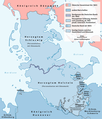
File:Karte Deutsch-Dänischer Krieg.png

Page contents not supported in other languages.
De Wikipedia

Original file(2,083 × 2,439 pixeles, dimension del file: 348 KB, tip MIME: image/png)

Ti file es de Wikimedia Commons e posse esser usat per altri projectes. Li descrition in su págine de descrition es monstrat in infra.

Descrition

Descrition
Deutsch: Karte der Grenzänderungen durch den Deutsch-Dänischen Krieg - ohne Einbeziehung der Königlichen Enklaven
English: Map of the boundary changes after the Second Schleswig War - without the danish-royal enclaves
Date
Fonte

Propri ovre, using

  • Großer Atlas zur Weltgeschichte, Westermann Schulbuchverlag
  • United States National Imagery and Mapping Agency data
Autor NordNordWest
Permission:
(Reusant ti-ci file)

I have published this file as author NordNordWest under the "CC-BY-SA-3.0-DE" in Wikipedia. This means that free, commercial usage outside of Wikipedia is permitted under the following licence terms:

Please send me a specimen copy or the URL of the website where the file is used.

Please write an email to nnwest[at]web.de if you

  • need my postal address for sending a specimen copy
  • have further questions about the terms of the licence

PS: In case of refusal of the above terms the author reserves the right to take legal action.

w:en:Creative Commons
atribution distribuer in conditiones de egal autorisation
This file is licensed under the Creative Commons Attribution-Share Alike 3.0 Germany license.
Vu es líber:
  • distribuer – a copiar, distribuer e transmisser li labor
  • remixter – adaptar li ovre
Sub li conditiones quam seque:
  • atribution – Vu deve dar li credite convenent, provider un catenun por li autorisation, e indicar si changes esset fat.

Vu posse far in qualcunc forme rasonabil, ma ne de forma que suggeste que li autorisator indossa vu o tui usu.

  • distribuer in conditiones de egal autorisation – Si vu remixter, transformar, o constructer sur li materiale, vu deve distribuer tui contributiones sub li autorisation identic o campatabil quam li original.
w:en:Creative Commons
atribution distribuer in conditiones de egal autorisation
Vu es líber:
  • distribuer – a copiar, distribuer e transmisser li labor
  • remixter – adaptar li ovre
Sub li conditiones quam seque:
  • atribution – Vu deve dar li credite convenent, provider un catenun por li autorisation, e indicar si changes esset fat.

Vu posse far in qualcunc forme rasonabil, ma ne de forma que suggeste que li autorisator indossa vu o tui usu.

  • distribuer in conditiones de egal autorisation – Si vu remixter, transformar, o constructer sur li materiale, vu deve distribuer tui contributiones sub li autorisation identic o campatabil quam li original.
Other versions file:Karte Deutsch-Dänischer Krieg.svg for translations
Kartenwerkstatt
This map has been made or improved in the German Kartenwerkstatt (Map Lab). You can propose maps to improve as well.

Captions

Add a one-line explanation of what this file represents

Items portrayed in this file

depicts anglesi

copyrighted anglesi

inception anglesi

13 octobre 2010

MIME type anglesi

image/png

Versiones del file

Clacca a un date/témpore por vider ti version.

Version deMiniaturaDimensionesUsatorComentarie
actual10:12, 14 octobre 2010Miniatura del version de 10:12, 14 octobre 20102,083 × 2,439 (348 KB)NordNordWestc
19:07, 13 octobre 2010Miniatura del version de 19:07, 13 octobre 20101,000 × 1,171 (141 KB)NordNordWestc
17:54, 13 octobre 2010Miniatura del version de 17:54, 13 octobre 20101,000 × 1,171 (141 KB)NordNordWest== {{int:filedesc}} == {{Information |Description= {{de|Karte der Grenzänderungen durch den Deutsch-Dänischen Krieg}} {{en|Map of the boundary changes after the Second Schleswig War}} |Sourc

Li sequent págine usa ti file:

Usu global del file

Li altri wikis a sequer usa ti-ci file: