
File:Mahe island 76.jpg
Nequant resolution max alt disponibil.
Mahe_island_76.jpg (423 × 559 pixeles, dimension del file: 56 KB, tip MIME: image/jpeg)
Descrition
| Descrition |
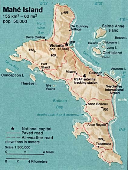
English: Topographic map of Mahé, main island of the Seychelles. |
| Date | |
| Fonte | http://www.lib.utexas.edu/maps/islands_oceans_poles/mahe_island_76.jpg |
| Autor | CIA |
Autorisation
This image is in the public domain because it contains materials that originally came from the United States Central Intelligence Agency's World Factbook.
|
 |
Versiones del file
Clacca a un date/témpore por vider ti version.
| Version de | Miniatura | Dimensiones | Usator | Comentarie | |
|---|---|---|---|---|---|
| actual | 12:33, 19 decembre 2009 | | 423 × 559 (56 KB) | Ratzer | {{Information |Description={{en|1=topographic map of Mahé, Seychelles (main island)}} |Source=http://www.lib.utexas.edu/maps/islands_oceans_poles/mahe_island_76.jpg |Author=CIA |Date=1976 |Permission= |other_versions= }} Category:Seychelles |
Usu del file
Li sequent págine usa ti file:
Usu global del file
Li altri wikis a sequer usa ti-ci file:
- Usu in ar.wikipedia.org
- Usu in az.wikipedia.org
- Usu in da.wikipedia.org
- Usu in de.wikipedia.org
- Usu in es.wikipedia.org
- Usu in fa.wikipedia.org
- Usu in fi.wikipedia.org
- Usu in fr.wikipedia.org
- Usu in hu.wikipedia.org
- Usu in ka.wikipedia.org
- Usu in nl.wikipedia.org
- Usu in ru.wikipedia.org
- Usu in sv.wikipedia.org
- Usu in uk.wikipedia.org