
File:PAK orthographic.svg

Size of this PNG preview of this SVG file: 553 × 553 pixeles. Altri resolutiones: 240 × 240 pixeles | 480 × 480 pixeles | 768 × 768 pixeles | 1,024 × 1,024 pixeles | 2,048 × 2,048 pixeles.
Original file ((file SVG, nominalmen 553 × 553 pixeles, mesura de file: 451 KB))
Descrition
| Descrition |
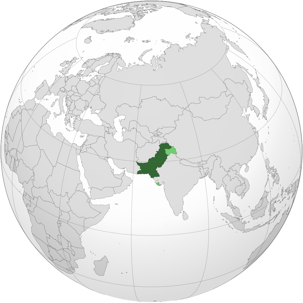
English: Orthographic map of Pakistan. Official source for claimed territories
Administered territory
Claimed territories اردو: پاکستان کا آرتھوگرافک نقشہ
زیر انتظام علاقہ
دعوی کردہ علاقے Français : Carte orthographique du Pakistan
Territoires administrés
Territoires revendiqués |
| Date | |
| Fonte | Propri ovre |
| Autor | Maanshen |
.svg)
.svg)
.svg)
.svg)
.svg)
.svg)
.svg)
.svg)
.svg)
.svg)
.svg)
.svg)
.svg)
.svg)
.svg)
.svg)
.svg)
.svg)
.svg)
.svg)
.svg)
.svg)
.svg)
.svg)
.svg)
.svg)
.svg)
.svg)
.svg)
.svg)
.svg)
.svg)
.svg)
.svg)
.svg)
.svg)
.svg)
.svg)
.svg)
.svg)
.svg)
.svg)
.svg)
.svg)
.svg)
.svg)
.svg)
.svg)
.svg)
.svg)
.svg)
.svg)
.svg)
.svg)
.svg)
.svg)
.svg)
.svg)
.svg)
.svg)
.svg)
.svg)
.svg)
.svg)
.svg)
.svg)
.svg)
.svg)
.svg)
.svg)
.svg)
.svg)
.svg)
.svg)

.svg)

.svg)

.svg)
.svg)
.svg)
.svg)
.svg)
.svg)
.svg)


.svg)
.svg)
.svg)
.svg)
.svg)
.svg)
.svg)

.svg)
.svg)
.svg)
.svg)
.svg)
.svg)
.svg)
.svg)
.svg)
.svg)

.svg)
.svg)
.svg)
.svg)
.svg)
.svg)
.svg)
_without_national_boundaries.svg)
.svg)
.svg)
.svg)
.svg)
.svg)
.svg)

.svg)
.svg)
.png)
.svg)
.svg)
.svg)
.svg)

.svg)
.svg)
.svg)
.svg)
.svg)
.svg)
.svg)
.svg)
.svg)
.svg)
.svg)

.svg)
.svg)
.svg)
.svg)
.svg)
.svg)
.svg)
.svg)
.svg)

.svg)
.svg)

.svg)
.svg)
.svg)
.svg)
.svg)
.svg)
.svg)
.svg)
.svg)
.svg)
.svg)
.svg)
.svg)
.svg)
.svg)
.svg)
.svg)
.svg)
.svg)
.svg)
.svg)
.svg)
.svg)
.svg)
.svg)
.svg)
.svg)
_-_Crimea_disputed.svg)
.svg)
.svg)
.svg)
.svg)
.svg)
.svg)
.svg)
.svg)
.svg)
.svg)
.svg)
_political.svg)
.svg)
.svg)
.svg)
.svg)
_-_Crimea_disputed_-_no_borders.svg)
.svg)
.svg)
.svg)
.svg)
.svg)
.svg)
.svg)
.svg)
.svg)
.svg)
.svg)

.svg)
.svg)
.svg)

.png)
.svg)
.svg)
.svg)
.svg)
.svg)
.svg)
.svg)
.svg)
.svg)
.svg)
.svg)
.svg)
.svg)
.svg)
.svg)
.svg)
.svg)
.svg)
.svg)
.svg)
.svg)
.svg)
.svg)
.svg)
.svg)
.svg)
.svg)
.svg)
.svg)
.svg)
.svg)
.svg)
.svg)
.svg)
.png)
.svg)
.svg)
.svg)
_(orthographic_projection).png)
| Orthographic projections maps created by Ssolbergj |
|---|
| Orthographic projections maps created by Ssolbergj: |
.svg)
.svg)
Autorisation
I, the copyright holder of this work, hereby publish it under the following license:
This file is licensed under the Creative Commons Attribution-Share Alike 4.0 International license.
- Vu es líber:
- distribuer – a copiar, distribuer e transmisser li labor
- remixter – adaptar li ovre
- Sub li conditiones quam seque:
- atribution – Vu deve dar li credite convenent, provider un catenun por li autorisation, e indicar si changes esset fat.
Vu posse far in qualcunc forme rasonabil, ma ne de forma que suggeste que li autorisator indossa vu o tui usu.
- distribuer in conditiones de egal autorisation – Si vu remixter, transformar, o constructer sur li materiale, vu deve distribuer tui contributiones sub li autorisation identic o campatabil quam li original.
Versiones del file
Clacca a un date/témpore por vider ti version.
| Version de | Miniatura | Dimensiones | Usator | Comentarie | |
|---|---|---|---|---|---|
| actual | 04:10, 22 januar 2024 | | 553 × 553 (451 KB) | Zinderboff | Reverted to version as of 18:02, 8 July 2023 (UTC) |
| 04:10, 21 januar 2024 |  | 553 × 553 (448 KB) | CD967119 | nobody talkin about it | |
| 18:02, 8 julí 2023 |  | 553 × 553 (451 KB) | Infrish 2 | Reverted to version as of 22:15, 8 March 2023 (UTC)Their official map shows it | |
| 22:46, 17 junio 2023 |  | 553 × 553 (448 KB) | Hellorld4 | Reverted to version as of 05:38, 20 February 2023 (UTC) Junagadh is not disputed territory | |
| 22:15, 8 marte 2023 |  | 553 × 553 (451 KB) | Red-tailed hawk | Reverted to version as of 15:30, 31 January 2023 (UTC) Officially annexed it has been, but that doesn't mean Pakistan doesn't claim it. See: <https://thehimalayantimes.com/world/pakistan-unveils-new-political-map-claiming-jammu-india-retorts>. | |
| 05:38, 20 februar 2023 |  | 553 × 553 (448 KB) | 5ysksos6 | Reverted to version as of 09:46, 20 December 2022 (UTC). Junagarh was annexed officially to India and is not claimed by Pakistan. | |
| 15:30, 31 januar 2023 |  | 553 × 553 (451 KB) | XavierGreen | Reverted to version as of 15:52, 20 May 2022 (UTC) Pakistani official maps include Jundagah | |
| 09:46, 20 decembre 2022 |  | 553 × 553 (448 KB) | Jargo Nautilus | Reverted to version as of 04:42, 10 March 2022 (UTC) Reverted to remove Junagadh as per discussion at "List of territorial disputes" Wikipedia article talk page | |
| 15:52, 20 may 2022 |  | 553 × 553 (451 KB) | Crab2814 | Read the source provided in the file description area. | |
| 04:42, 10 marte 2022 |  | 553 × 553 (448 KB) | Maanshen | Uploaded own work with UploadWizard |
Usu del file
Hay nequant págine que usa ti file.
Usu global del file
Li altri wikis a sequer usa ti-ci file:
- Usu in ar.wikipedia.org
- Usu in arz.wikipedia.org
- Usu in ast.wikipedia.org
- Usu in bn.wikipedia.org
- Usu in ca.wikipedia.org
- Usu in dtp.wikipedia.org
- Usu in el.wikipedia.org
- Usu in en.wikipedia.org
- Usu in en.wiktionary.org
- Usu in es.wikipedia.org
- Usu in fa.wikipedia.org
- Usu in fr.wikipedia.org
- Usu in ia.wikipedia.org
- Usu in incubator.wikimedia.org
- Usu in it.wikipedia.org
- Usu in kge.wikipedia.org
- Usu in ko.wikipedia.org
- Usu in lt.wikipedia.org
- Usu in mn.wikipedia.org
- Usu in pt.wikipedia.org
- Usu in ro.wikipedia.org
- Usu in ru.wikipedia.org
- Usu in sat.wikipedia.org
- Usu in sa.wikipedia.org
- Usu in simple.wikipedia.org
- Usu in simple.wiktionary.org
- Usu in sq.wikipedia.org
- Usu in ta.wikipedia.org
- Usu in tcy.wikipedia.org
.svg)
Vider plu del usu global de ti-ci file.