
File:Ragusa.png
Nequant resolution max alt disponibil.
Ragusa.png (675 × 354 pixeles, dimension del file: 128 KB, tip MIME: image/png)
Descrition
| Descrition |
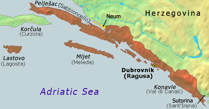
Hrvatski: Karta Dubrovačke republike iz 1808
English: Map of the Republic of Ragusa as of 1808 |
||
| Date | |||
| Fonte | Demis Map Server (http://www2.demis.nl/mapserver/mapper.asp) data with additional annotations and modifications by self. | ||
| Autor | ChrisO | ||
| Other versions |
Derivative works of this file: Ragusa-IT.png
|


|
This historical map image could be re-created using vector graphics as an SVG file. This has several advantages; see Commons:Media for cleanup for more information. If an SVG form of this image is available, please upload it and afterwards replace this template with
{{vector version available|new image name}}.
It is recommended to name the SVG file “Ragusa.svg”—then the template Vector version available (or Vva) does not need the new image name parameter. |
Versiones del file
Clacca a un date/témpore por vider ti version.
| Version de | Miniatura | Dimensiones | Usator | Comentarie | |
|---|---|---|---|---|---|
| actual | 07:51, 21 octobre 2020 | | 675 × 354 (128 KB) | Claude Zygiel | Ragusan / Venetian names also (official until 1918) |
| 19:49, 6 februar 2020 |  | 675 × 354 (114 KB) | Ceha | Klek was part of Dubrovnik Republic. Tip of the peninsula is in Croatia, while the rest is in BiH. The same goes for the small island of Lastavica, which is today in Montenegro... https://www.google.com/maps/place/Mamula/@42.3952695,18.4181714,11z/data=!4m5!3m4!1s0x134c24e629d0b6ed:0x1d78b87fc20846b1!8m2!3d42.3954043!4d18.5585609 | |
| 21:15, 8 septembre 2010 |  | 675 × 354 (65 KB) | DIREKTOR | fix | |
| 17:02, 25 novembre 2006 |  | 675 × 354 (53 KB) | Tieum512 | {{Information |Description=Map of the Republic of Ragusa as of 1808 Based on Demis Web Map Server output |Source=http://en.wikipedia.org/wiki/Image:Ragusa.png |Date= |Author=User:ChrisO |Permission=GFDL |other_versions= }} |
Usu del file
Li sequent págine usa ti file:
Usu global del file
Li altri wikis a sequer usa ti-ci file:
- Usu in an.wikipedia.org
- Usu in ar.wikipedia.org
- Usu in ast.wikipedia.org
- Usu in azb.wikipedia.org
- Usu in az.wikipedia.org
- Usu in be-tarask.wikipedia.org
- Usu in be.wikipedia.org
- Usu in bg.wikipedia.org
- Usu in br.wikipedia.org
- Usu in bs.wikipedia.org
- Usu in ca.wikipedia.org
- Usu in cs.wikipedia.org
- Usu in da.wikipedia.org
- Usu in de.wikipedia.org
- Usu in el.wikipedia.org
- Usu in en.wikipedia.org
- Usu in eo.wikipedia.org
- Usu in es.wikipedia.org
- Usu in et.wikipedia.org
- Usu in eu.wikipedia.org
- Usu in fa.wikipedia.org
- Usu in fi.wikipedia.org
- Usu in fr.wikipedia.org
- Usu in fy.wikipedia.org
- Usu in gl.wikipedia.org
- Usu in he.wikipedia.org
- Usu in hu.wikipedia.org
- Usu in ia.wikipedia.org
- Usu in id.wikipedia.org
- Usu in it.wikipedia.org
- Usu in ja.wikipedia.org
- Usu in ko.wikipedia.org
- Usu in li.wikipedia.org
- Usu in mk.wikipedia.org
- Usu in ms.wikipedia.org
- Usu in mt.wikipedia.org
Vider plu del usu global de ti-ci file.