
File:Topographic map of Saint Helena-en.svg

Size of this PNG preview of this SVG file: 740 × 600 pixeles. Altri resolutiones: 296 × 240 pixeles | 592 × 480 pixeles | 948 × 768 pixeles | 1,264 × 1,024 pixeles | 2,527 × 2,048 pixeles | 802 × 650 pixeles.
Original file ((file SVG, nominalmen 802 × 650 pixeles, mesura de file: 583 KB))
Descrition
| Descrition |
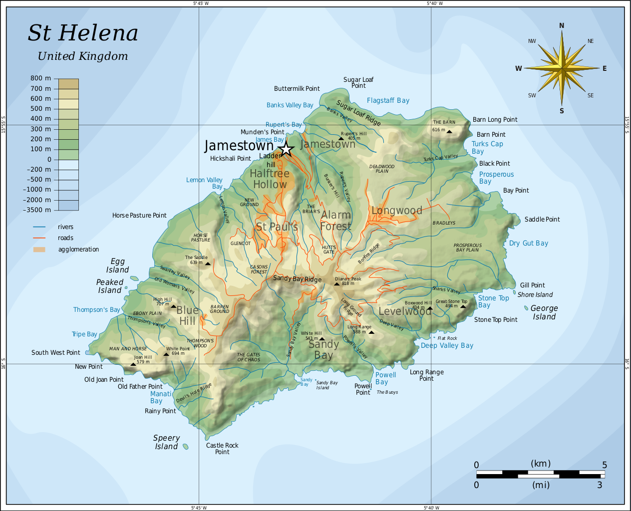
English: Topographic map of the British island of Saint Helena. |
| Date | |
| Fonte |
Self-made in Inkscape. Based on several sources:
|
| Autor | Oona Räisänen (Mysid) |
| Other versions |
Derivative works of this file: |

|
This SVG file contains embedded text that can be translated into your language, using any capable SVG editor, text editor or the SVG Translate tool. For more information see: About translating SVG files. |
Autorisation
I, the copyright holder of this work, hereby publish it under the following licenses:
Ti file is autorisat sub li autorisation Creative Commons - Atribution-Distribution in Conditiones de Egal Autorisation 3.0 Non-Adaptat.
- Vu es líber:
- distribuer – a copiar, distribuer e transmisser li labor
- remixter – adaptar li ovre
- Sub li conditiones quam seque:
- atribution – Vu deve dar li credite convenent, provider un catenun por li autorisation, e indicar si changes esset fat.
Vu posse far in qualcunc forme rasonabil, ma ne de forma que suggeste que li autorisator indossa vu o tui usu.
- distribuer in conditiones de egal autorisation – Si vu remixter, transformar, o constructer sur li materiale, vu deve distribuer tui contributiones sub li autorisation identic o campatabil quam li original.

|
Permission es concedet por copiar, distribuer e/o modificar ti document sub li conditiones del Autorisation de Documentation Líber del GNU, Version 1.2 o qualcunc version posteriori publicat per li Free Software Foundation; che nequant Section Ínvariant, nequant Textu de Covriment, e nequant Textu de Contra-Covriment. Un copie del autorisation es includet in li section nominat Autorisation de Documentation Líber del GNU. |
Vu posse selecter li autorisation de tui selection.
Versiones del file
Clacca a un date/témpore por vider ti version.
| Version de | Miniatura | Dimensiones | Usator | Comentarie | |
|---|---|---|---|---|---|
| actual | 05:54, 10 august 2010 | | 802 × 650 (583 KB) | Mysid | legend for roads, rivers, agglomeration |
| 21:42, 9 august 2010 |  | 802 × 650 (580 KB) | Mysid | bugfix #2 | |
| 21:40, 9 august 2010 |  | 802 × 650 (260 KB) | Mysid | bugfix | |
| 21:27, 9 august 2010 |  | 647 × 594 (579 KB) | Mysid | {{Information |Description={{en|1=Topographic map of the British island of w:Saint Helena.}} |Source=Self-made in Inkscape. Based on several sources. |Author=Mysid |Date=2010-08-10 |Permission= |other_versions= }} {{translation possi |
Usu del file
Li sequent págine usa ti file:
Usu global del file
Li altri wikis a sequer usa ti-ci file:
- Usu in af.wikipedia.org
- Usu in als.wikipedia.org
- Usu in ar.wikipedia.org
- Usu in arz.wikipedia.org
- Usu in ast.wikipedia.org
- Usu in bg.wikipedia.org
- Usu in bn.wikipedia.org
- Usu in bs.wikipedia.org
- Usu in ca.wikipedia.org
- Usu in ckb.wikipedia.org
- Usu in da.wikipedia.org
- Usu in el.wikipedia.org
- Usu in en.wikipedia.org
- Usu in eo.wikipedia.org
- Usu in es.wikipedia.org
- Usu in eu.wikipedia.org
- Usu in fa.wikipedia.org
- Usu in fi.wikipedia.org
- Usu in fy.wikipedia.org
- Usu in ga.wikipedia.org
- Usu in gl.wikipedia.org
- Usu in gv.wikipedia.org
- Usu in he.wikipedia.org
- Usu in hr.wikipedia.org
- Usu in hu.wikipedia.org
- Usu in hy.wikipedia.org
- Usu in io.wikipedia.org
- Usu in it.wikipedia.org
- Usu in ja.wikipedia.org
Vider plu del usu global de ti-ci file.