
File:Tour de France 2015 map-fr.svg

Size of this PNG preview of this SVG file: 498 × 600 pixeles. Altri resolutiones: 199 × 240 pixeles | 399 × 480 pixeles | 638 × 768 pixeles | 850 × 1,024 pixeles | 1,701 × 2,048 pixeles | 1,225 × 1,475 pixeles.
Original file ((file SVG, nominalmen 1,225 × 1,475 pixeles, mesura de file: 1.85 MB))
Descrition
| Descrition |
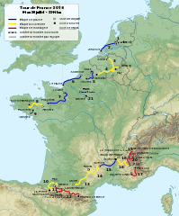
English: Roadmap of Tour de France 2015. Français : Carte du tracé du Tour de France 2015. |
||
| Date | |||
| Fonte |
|
||
| Autor | Sémhur (discussion) | ||
| Other versions |
| ||
| Atribution (required by the license) | © Sémhur / Wikimedia Commons / | ||
| SVG | W3C-validity not checked.
|
||
| Graphic Lab |

| Object location | | View this and other nearby images on: OpenStreetMap |
|---|
Autorisation
I, the copyright holder of this work, hereby publish it under the following licenses:
| Copyleft: This work of art is free; you can redistribute it and/or modify it according to terms of the Free Art License. You will find a specimen of this license on the Copyleft Attitude site as well as on other sites. |
This file is licensed under the Creative Commons Attribution-Share Alike 4.0 International, 3.0 Unported, 2.5 Generic, 2.0 Generic and 1.0 Generic license.
- Vu es líber:
- distribuer – a copiar, distribuer e transmisser li labor
- remixter – adaptar li ovre
- Sub li conditiones quam seque:
- atribution – Vu deve dar li credite convenent, provider un catenun por li autorisation, e indicar si changes esset fat.
Vu posse far in qualcunc forme rasonabil, ma ne de forma que suggeste que li autorisator indossa vu o tui usu.
- distribuer in conditiones de egal autorisation – Si vu remixter, transformar, o constructer sur li materiale, vu deve distribuer tui contributiones sub li autorisation identic o campatabil quam li original.
Vu posse selecter li autorisation de tui selection.
Versiones del file
Clacca a un date/témpore por vider ti version.
| Version de | Miniatura | Dimensiones | Usator | Comentarie | |
|---|---|---|---|---|---|
| actual | 18:33, 12 august 2015 | | 1,225 × 1,475 (1.85 MB) | Sémhur | L'étape 4 est en accidentée (et non plus plaine), l'étape 10 aussi en accidentée (et non montagne) et l’étape 13 encore en accidentée (et non en plaine). Cf. page 12 du règlement (http://www.letour.fr/le-tour/2015/docs/TDF15_Reglement-BD.pdf) |
| 09:55, 19 julí 2015 |  | 1,225 × 1,475 (1.85 MB) | Sémhur | 17 => 20 | |
| 20:53, 8 april 2015 |  | 1,225 × 1,475 (1.85 MB) | Sémhur | == {{int:filedesc}} == {{Information |Description={{Multilingual description |en= Roadmap of Tour de France 2015. |fr= Carte du tracé du Tour de France 2015. }} |Source= * [[:File:Fond de carte T... |
Usu del file
Li sequent págine usa ti file:
Usu global del file
Li altri wikis a sequer usa ti-ci file:
- Usu in cy.wikipedia.org
- Usu in de.wikipedia.org
- Usu in fi.wikipedia.org
- Usu in fr.wikipedia.org
- Usu in hr.wikipedia.org
- Usu in it.wikipedia.org
- Usu in ja.wikipedia.org
- Usu in nl.wikipedia.org
- Usu in sv.wikipedia.org